
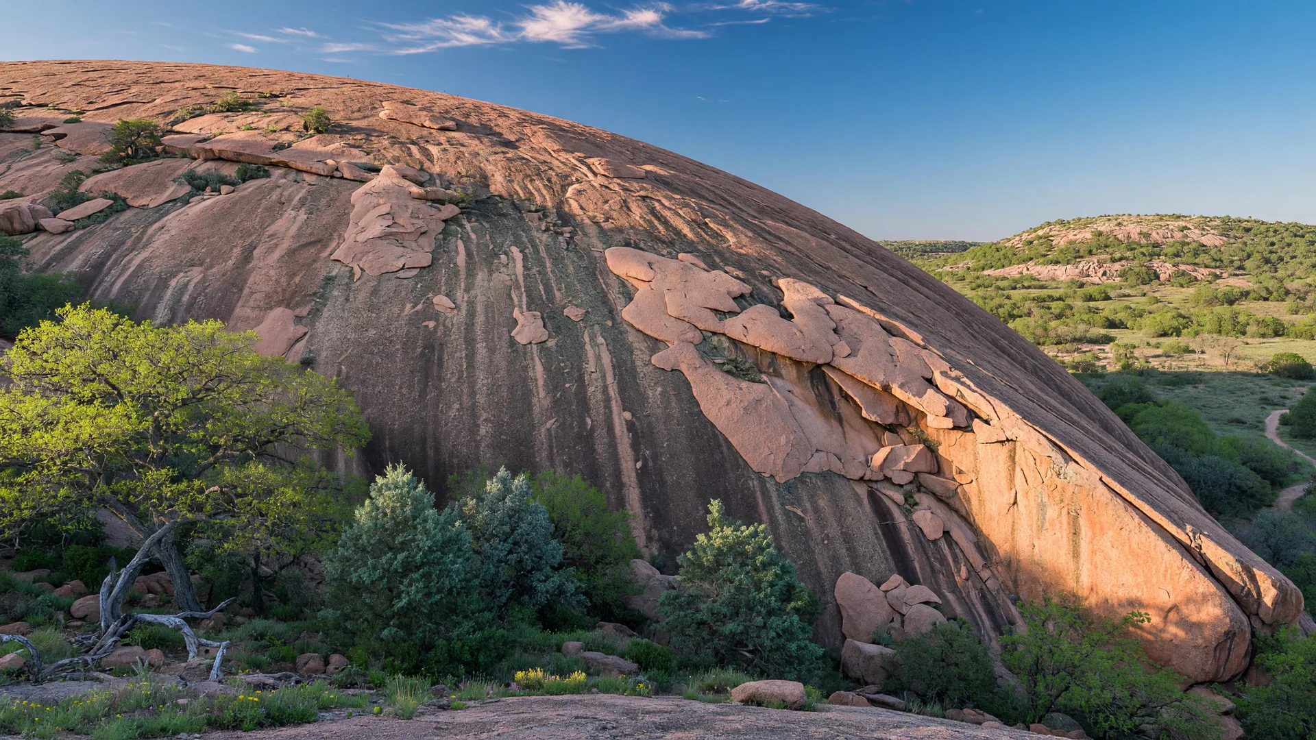
Enchanted Rock State Natural Area sits roughly 63 miles northwest of downtown Boerne, just north of Fredericksburg on Ranch Road 965. The centerpiece — a massive pink granite dome that rises 425 feet above the surrounding terrain — is one of the most recognizable landmarks in Texas [1][2]. The dome covers approximately 640 acres at its base and is the largest pink granite monolith in the United States [3].
For anyone considering a move to the Hill Country, Enchanted Rock is worth understanding for reasons that go beyond recreation. The rock is part of the Llano Uplift, a geological region where some of the oldest exposed rock in North America surfaces at ground level [4]. The Town Mountain Granite that forms the dome solidified from magma roughly seven miles underground about 1.08 billion years ago [4][5]. The same granite formations extend across much of the Texas Hill Country basement geology, and the Llano Uplift region has shaped the area's water systems, soil chemistry, and mineral composition for hundreds of millions of years. Seeing the rock in person makes the deep-time scale of the Hill Country landscape tangible in a way that maps and descriptions cannot convey.
What Enchanted Rock actually is
Enchanted Rock State Natural Area was designated a National Natural Landmark by the National Park Service in 1971 and opened as a state natural area in October 1978 [1][3]. The park is located at 16710 Ranch Road 965, Fredericksburg, TX 78624, approximately 18 miles north of Fredericksburg's town square [1][2].
The granite dome itself is the primary feature, but the park has expanded significantly in recent years. Major land acquisitions in 2022, 2024, and 2025 grew the park from its original 1,640.5 acres to approximately 5,388 acres [2][6]. This expansion added significant backcountry terrain, additional trail mileage, and protected critical watershed and wildlife habitat in the surrounding granite hill complex.
The name "Enchanted Rock" comes from Native American oral tradition. The Comanche and Tonkawa tribes both considered the rock a place of spiritual significance. The groaning and creaking sounds the rock makes at night — caused by thermal contraction as the granite cools after a hot day — were attributed to spirits or supernatural forces [1][2]. The rock was added to the National Register of Historic Places as an Archaeological District in 1984, with more than 400 archaeological sites identified within the park and 120 designated as State Archeological Landmarks [1][7]. Evidence of human activity on and around the rock dates back at least 11,000 to 12,000 years, including bedrock mortars used by prehistoric peoples to grind acorns and seeds [7].
Enchanted Rock receives approximately 300,000 visitors annually, making it one of the most visited state parks in Texas [2][8]. Because of this popularity, day-use reservations are required on weekends and during peak seasons, and the park frequently reaches capacity by mid-morning during spring and fall.
How to get there from Boerne
From downtown Boerne, the most direct route heads west on I-10 for approximately 23 miles to Comfort, then north on TX-27 for about 12 miles to US-87, continuing north through Kerrville toward Fredericksburg. At Fredericksburg, head north on Ranch Road 965 for 18 miles to the park entrance [9]. The total distance is roughly 63 miles, with a drive time of about one hour and fifteen minutes under normal conditions.
A secondary route follows US-281 north from Boerne to TX-16, heading west through Johnson City and Stonewall to Fredericksburg, then north on RR 965. This route is slightly longer but passes through several notable Hill Country towns and the LBJ National Historical Park near Stonewall.
From Fair Oaks Ranch, add roughly five miles and five to eight minutes. From San Antonio's far north side, plan on approximately 85 miles and one hour thirty minutes via I-10 West to Comfort and the same route from there.
| Starting Point | Distance | Drive Time | Best Route |
|---|---|---|---|
| Downtown Boerne | ~63 miles | ~70-80 min | I-10 W → Fredericksburg → RR 965 |
| Fair Oaks Ranch | ~67 miles | ~75-85 min | I-10 W → Fredericksburg → RR 965 |
| Fredericksburg | ~18 miles | ~25-30 min | RR 965 north |
| San Antonio (north side) | ~85 miles | ~90-100 min | I-10 W → Fredericksburg → RR 965 |
| Austin | ~100 miles | ~100-110 min | US-290 W → Fredericksburg → RR 965 |
Distances are approximate and based on standard driving routes.
What to see and do
The summit hike
The Summit Trail is the park's signature experience. It is a 1.3-mile round trip from the trailhead to the top of the dome, rated moderate in difficulty [1][10]. The trail follows a well-worn path up the exposed granite face, gaining approximately 425 feet of elevation with sections of smooth rock that can be steep. Hikers follow painted markers (called "painted steps") that guide the route across the bare granite — staying on the marked path helps prevent trail braiding and minimizes ecological impact on the fragile lichen and moss communities that live on the rock surface [10].
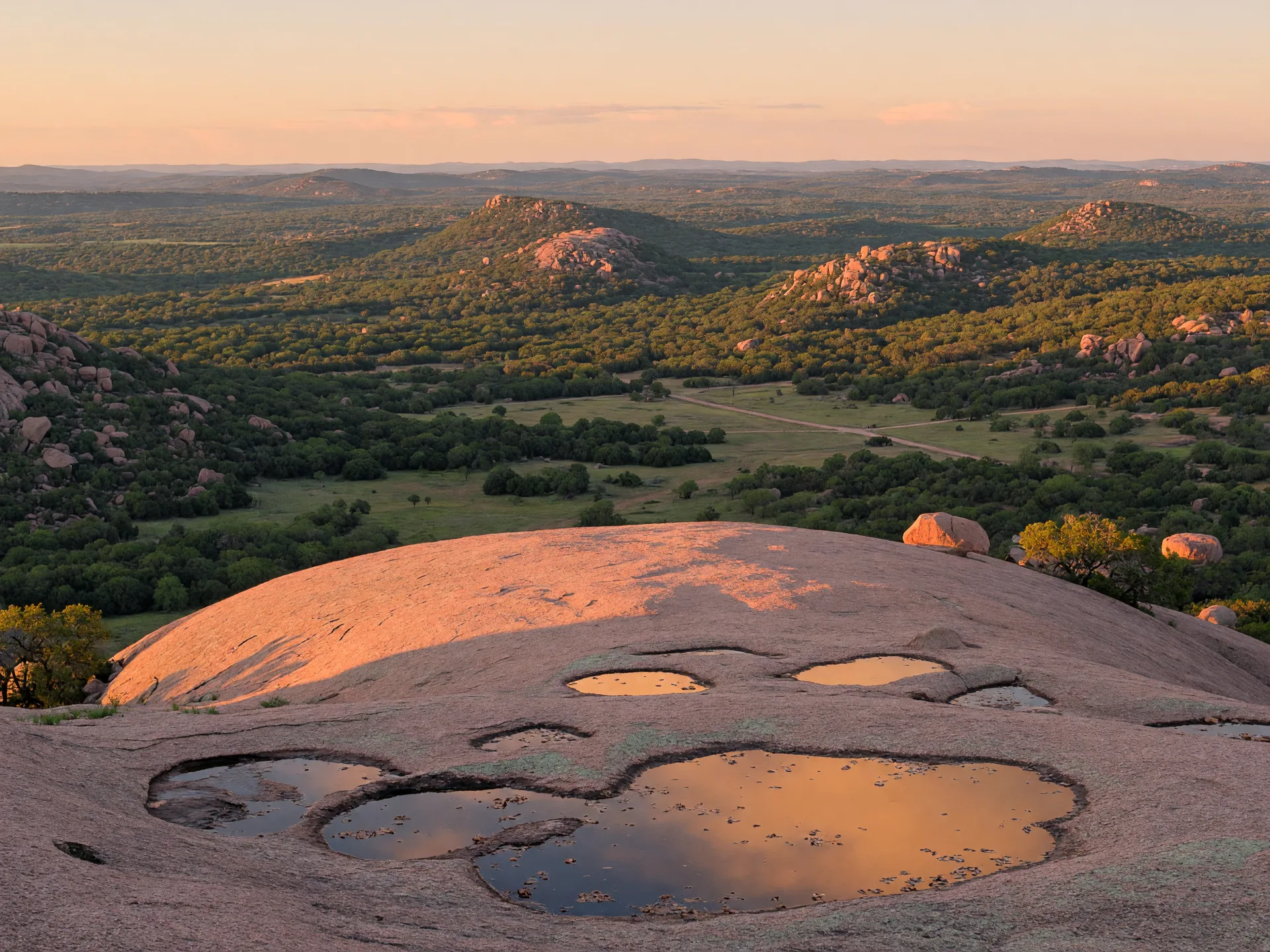
From the summit, at 1,825 feet above sea level, the view extends across the Texas Hill Country for miles in every direction. On clear days, the distant outlines of other granite domes in the Llano Uplift — including Little Rock and Turkey Peak — are visible [1][10]. The summit is also dotted with shallow depressions called vernal pools (or "potholes") that collect rainwater and support tiny ecosystems of algae, invertebrates, and specialized plants called quillworts that have adapted to the extreme wet-dry cycle [1][11].
The Summit Trail takes most visitors 30 to 45 minutes up and 20 to 30 minutes down. Early morning or late afternoon are the best times for comfortable temperatures and good photography light. Pets are not permitted on the Summit Trail — the bare granite surface can reach surface temperatures well over 100 degrees Fahrenheit in summer, and there is no shade or available water [1].
Other hiking trails
The park's trail system has expanded with the recent land acquisitions and now offers roughly 11 miles of marked trails across varied terrain [1][12]. Key trails include:
- Loop Trail (4.6 miles, moderate to difficult) — Circumnavigates the base of Enchanted Rock, passing through oak-juniper woodland, crossing seasonal creek beds, and offering views of the dome from every angle. This trail stays open until 10 PM and is popular for sunset and full-moon hikes [10][12].
- Interpretive Loop (0.5 miles, easy) — A short paved and boardwalk trail near the park headquarters with interpretive signs covering the park's geology, history, and ecology. Wheelchair accessible. Good for families with young children [10].
- Turkey Pass Trail (0.7 miles, moderate) — Connects the base of the dome to the eastern side of the park. Crosses a granite saddle between Enchanted Rock and Little Rock with good wildflower displays in spring [10][12].
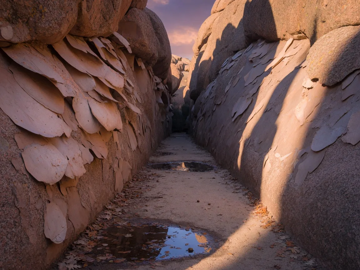
- Echo Canyon Trail (0.7 miles, moderate) — A narrow granite corridor on the north side of the dome. The canyon's polished walls create the pronounced acoustics that gave it its name. Accessible from the Loop Trail [10][12].
Rock climbing
Enchanted Rock is one of the premier traditional climbing destinations in Texas, with over 140 documented routes ranging from beginner-friendly slabs to advanced crack climbs on the dome's steep eastern wall [1][13]. The granite exfoliation features — concave dihedrals, vertical crack systems, and gently sloping slabs — offer a variety of climbing experiences. All climbers must register at park headquarters before climbing, and some routes are closed seasonally to protect nesting raptors [1][13]. Climbers need their own gear; there are no equipment rentals or guide services inside the park.
Camping
The park offers 36 walk-in tent campsites, all located approximately 300 to 900 feet from the parking area [1][14]. Each site has a fire ring and picnic table. Restrooms with cold-water showers and drinking water are available nearby. There are no RV hookups or drive-up campsites — all camping requires carrying gear a short distance.
Camping fees are $10 per night per person (ages 13 and older), plus the daily entrance fee [14]. Reservations are strongly recommended and can be made through the Texas State Parks reservation system. Weekend sites typically book up weeks in advance during the March-through-October peak season.
Stargazing
Enchanted Rock is designated as an International Dark Sky Park by the International Dark-Sky Association [1][15]. The park's remote location and low ambient light levels make it one of the premier stargazing locations within driving distance of both San Antonio and Austin. The Loop Trail stays open until 10 PM, allowing night hiking and access to viewing areas away from the parking lot lights. New moon weekends offer the darkest conditions, and the park occasionally hosts ranger-led astronomy programs [15][16].
The lack of light pollution also benefits wildlife. The park is home to numerous bat species that emerge at dusk from crevices in the granite, offering an additional natural spectacle for evening visitors [1].
Wildlife and birding
The park's granite outcrops and oak-juniper woodlands support a range of wildlife including white-tailed deer, eastern cottontail rabbits, rock squirrels, and Texas spiny lizards that are well-camouflaged against the pink granite [1][11]. Bird species include golden-cheeked warblers, black-capped vireos, and rufous-crowned sparrows [17]. The granite exfoliation features create microhabitats for rare plants including the Enchanted Rock quillwort, a small aquatic fern that grows exclusively in the vernal pools on the dome's summit [11].
Hours, fees, and practical details
| Detail | Information |
|---|---|
| Address | 16710 Ranch Road 965, Fredericksburg, TX 78624 |
| Phone | (325) 247-3903 |
| Gate Opens | 6:30 AM daily |
| Gate Closes / Exit by | Closed at 8:00 PM / Day-use exit by 10:00 PM |
| Day-Use Fee (Ages 13+) | $8.00 per person per day |
| Children 12 & Under | Free |
| Texas State Parks Pass | $70/year — covers day-use entry for pass holder and guests |
| Acreage | Approx. 5,388 acres (expanded 2022-2025) |
| Designation | National Natural Landmark, International Dark Sky Park |
| Trails | ~11 miles of hiking trails |
| Reservations | Required for day use on weekends & holidays — often required daily Mar-Oct |
Fees and policies are subject to change. Check the TPWD website before visiting.
Reservation system — plan ahead
Enchanted Rock operates a timed-entry reservation system that is worth understanding before making the drive. Day-use reservations are required on weekends and most state holidays year-round, and the park frequently implements daily reservation requirements during the busy spring and fall seasons [1][18]. The park's 300,000 annual visitors concentrate heavily on Saturdays between March and June and September through November, when temperatures are most comfortable [2][8].
Reservations for day use and camping open on a rolling schedule through the Texas State Parks reservation system — typically up to 30 days in advance for day use and 5 months in advance for camping [18]. During peak weekends, day-use slots often sell out within hours of becoming available. A limited number of same-day walk-up permits are available at the gate on weekdays when the park is not at capacity.
The practical takeaway: if you are planning a weekend visit during spring or fall, book your reservation as early as possible. Weekday visits, particularly Tuesday through Thursday, are far more relaxed and rarely hit capacity.
What to bring and practical tips
Footwear for the dome: The Summit Trail crosses bare granite that gets hot — very hot — in direct sun. Sturdy hiking shoes or trail runners with good grip are important. The granite exfoliation surface can be slippery, particularly in sections where fine gravel has accumulated on the smooth rock. Avoid smooth-soled sneakers or sandals for the summit hike [1][10].
Water and sun protection: There is no shade on the granite dome itself. Summer surface temperatures on the rock can exceed 120 degrees Fahrenheit. Bringing at least one gallon of water per person is not excessive for a full day that includes the summit hike. Sunscreen, a wide-brimmed hat, and light long-sleeved clothing make the difference between an enjoyable outing and a difficult one [1][10].
Start early or go late: Sunrise and sunset are the best times to hike the dome — the temperatures are lower, the light for photography is better, and the crowds are thinner. The park opens at 6:30 AM, which allows early risers to be on the summit for sunrise. Evening visits that include the sunset hike followed by stargazing are popular during long summer days.
Leave no trace: The fragile lichen and moss communities on the granite surface take decades to recover from foot traffic. Staying on the marked painted steps and designated trails is critical to preserving the ecosystem [1][11].
Food and supplies: There are no food concessions or stores inside the park. Packing a cooler with lunch, snacks, and plenty of water is essential. Fredericksburg has full grocery stores and restaurants about 25 minutes south of the park, but stopping there on the way in rather than the way out is the more practical approach.
Weather awareness: The open granite dome is highly exposed to lightning. If thunderstorms are in the forecast, the summit and the exposed portions of the Loop Trail should be avoided. The park staff will close the summit trail during active lightning [1]. Conversely, the granite drains water quickly, and trails are typically usable within hours of most rain events.
Photography gear: The summit at sunrise or sunset provides exceptional photography conditions with warm-toned light on the pink granite. A polarizing filter can help manage glare off the rock surface. For astrophotography, the dark-sky designation means minimal light pollution — a tripod and wide-aperture lens on a new moon night are the basic setup [15][16].
Pets: Pets are permitted on leashes in the park but are not allowed on the Summit Trail. The granite surface temperatures and lack of shade make the summit unsafe for pets even on moderate-temperature days [1].
Seasonal timing: when to go
| Season | Best Activities | Notes |
|---|---|---|
| Spring Mar - May | Summit hiking, wildflowers, birding, camping | Peak visitation season. Wildflowers along park roads. Comfortable temperatures. Day-use reservations essential on weekends. Busiest time of year. |
| Summer Jun - Aug | Early morning summit hikes, stargazing, night hiking | Hottest months. Summit hikes best done before 9 AM or after 6 PM. Late-night stargazing excellent. Lower visitation midweek. Pack extra water. |
| Fall Sep - Nov | Summit hiking, climbing, camping, photography | Clear skies, mild temperatures, fewer crowds than spring. Best all-around season. Golden-hour photography on the dome is exceptional in October. |
| Winter Dec - Feb | Hiking, solitude, stargazing | Quietest season. Cold temperatures but generally clear. Best stargazing with longest nights. Occasional ice on the granite summit. Fewest crowds of the year. |
Why it matters if you are considering the Hill Country
Enchanted Rock is one of the most significant geological landmarks in Texas, and understanding it provides a window into the broader landscape dynamics of the Hill Country. The Town Mountain Granite exposed at Enchanted Rock is part of the Llano Uplift, a region where the oldest rocks in Texas — approximately 1.3 billion years old — are exposed at the surface [4][5]. This ancient granite basement underlies much of the Edwards Plateau, and its weathering over hundreds of millions of years has produced the mineral-rich soils, varied topography, and distinctive groundwater chemistry that define the Hill Country.
The same exfoliation processes visible on the dome — where the granite peels away in thin sheets like layers of an onion — are actively shaping the region's topography, creating the rock outcrops, boulder fields, and shallow soils that characterize much of the Hill Country landscape. For anyone evaluating land or property in the region, the relationship between bedrock geology and surface conditions is directly relevant to well drilling, foundation engineering, and septic system design.
The park's Dark Sky designation is also worth noting. As development in the Texas Hill Country continues to accelerate, true dark-sky locations within an hour of major population centers are becoming increasingly rare. Enchanted Rock's commitment to preserving natural nighttime darkness is both a recreational asset and an indicator of the conservation values that many landowners in the Fredericksburg and Llano areas take seriously [15][16].
For a combined day trip from Boerne, pairing Enchanted Rock with Fredericksburg makes practical sense. Fredericksburg's historic Main Street, with its German heritage architecture, wine tasting rooms, and local restaurants, is about 25 minutes south of the park along a scenic two-lane road. For visitors looking to extend the trip further, the LBJ State Park and National Historical Park in Stonewall lies about 30 minutes east of Fredericksburg on US-290, offering a complement of cultural and political history to go with the natural history at the rock. On the wine side, the stretch of US-290 between Johnson City and Fredericksburg is known as Texas Wine Country, with dozens of vineyards and tasting rooms that make for a well-rounded weekend itinerary.
Frequently asked questions
How far is Enchanted Rock from Boerne?
Approximately 63 miles northwest of downtown Boerne via I-10 West and Fredericksburg. The drive takes roughly 70 to 80 minutes under normal conditions. From Fair Oaks Ranch, add about 5 miles and 5 to 8 minutes [9].
Do I need a reservation to visit Enchanted Rock?
Day-use reservations are required on weekends and most holidays, and the park often requires them daily during peak seasons (March through May and September through November). Walk-up permits are available on weekdays when the park is below capacity, but arriving early is recommended. Reservations open 30 days in advance through the Texas State Parks reservation system [1][18].
How hard is the hike to the summit?
The Summit Trail is 1.3 miles round trip and rated moderate. It follows a marked route up the exposed granite face with sections of steep incline on bare rock. Most visitors complete the hike in 45 to 75 minutes round trip. There is no shade and the granite surface gets very hot — start early and bring plenty of water. Sturdy footwear with good grip is essential [1][10].
Can you climb the rock at Enchanted Rock?
Yes. Enchanted Rock is a premier traditional climbing destination with over 140 documented routes ranging from beginner slabs to advanced crack climbs. All climbers must register at park headquarters before climbing. Some routes close seasonally to protect nesting raptors. You need your own gear — there are no rentals or guides available on site [1][13].
What makes Enchanted Rock special geologically?
The dome is made of Town Mountain Granite that formed 1.08 billion years ago from magma cooling seven miles underground. It is part of the Llano Uplift, where ancient Precambrian rocks are exposed at the surface — some of the oldest exposed rock in North America. The dome's curved shape comes from exfoliation, where the granite peels into thin sheets as pressure is released from erosion of overlying rock [4][5].
Can you camp at Enchanted Rock?
Yes. The park offers 36 walk-in tent campsites located 300 to 900 feet from the parking area. Sites have fire rings and picnic tables. Restrooms with cold-water showers and drinking water are nearby. Camping costs $10 per night per person (13+) plus the entrance fee. No RV hookups or drive-up camping are available [1][14].
Sources
- [1] Texas Parks and Wildlife Department — Enchanted Rock State Natural Area. tpwd.texas.gov/state-parks/enchanted-rock
- [2] Wikipedia — Enchanted Rock. en.wikipedia.org/wiki/Enchanted_Rock
- [3] National Park Service — National Natural Landmarks: Enchanted Rock. nps.gov
- [4] Bureau of Economic Geology — Llano Uplift geology. beg.utexas.edu
- [5] Geology Virtual Trips — Enchanted Rock, Texas. geologyvirtualtrips.com
- [6] Texas Public Radio — There is now twice as much to love about Enchanted Rock (TPR, Jan 2025). tpr.org
- [7] Texas Parks & Wildlife Magazine — The History of Enchanted Rock. tpwmagazine.com
- [8] Texas State Parks — Enchanted Rock attendance data. tpwd.texas.gov
- [9] Google Maps — Directions from Boerne to Enchanted Rock. google.com/maps
- [10] TPWD — Enchanted Rock Trail Guide. tpwd.texas.gov
- [11] TPWD — Enchanted Rock Nature. tpwd.texas.gov
- [12] AllTrails — Best Trails in Enchanted Rock State Natural Area. alltrails.com
- [13] Mountain Project — Enchanted Rock climbing. mountainproject.com
- [14] ReserveAmerica — Enchanted Rock State Natural Area Camping. texasstateparks.reserveamerica.com
- [15] International Dark-Sky Association — Enchanted Rock State Natural Area Dark Sky Park. darksky.org
- [16] TPWD — Dark Sky Parks in Texas. tpwd.texas.gov
- [17] eBird — Enchanted Rock hotspot. ebird.org
- [18] Texas State Parks — Enchanted Rock Reservation Info. tpwd.texas.gov
Published August 14, 2026
Updated August 14, 2026