
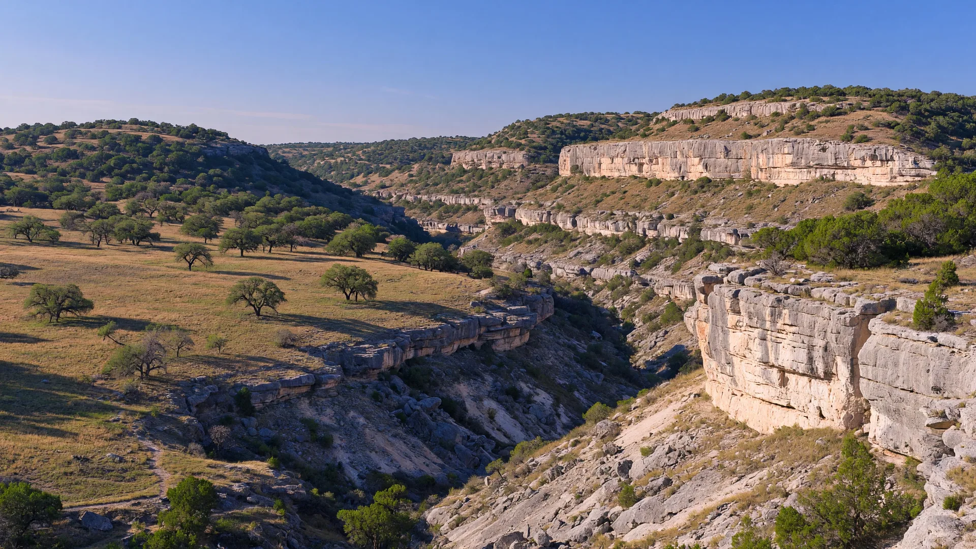
Government Canyon State Natural Area is one of the most strategically significant public lands in the Texas Hill Country — and not just for the hiking. Spanning over 12,000 acres on the western edge of San Antonio, it is the largest piece of protected public land in Bexar County and sits squarely within the Edwards Aquifer recharge zone, the geological system that supplies roughly half of San Antonio's drinking water [1][2]. The park offers more than 40 miles of trails through rugged limestone canyons, past historic homestead ruins, and along ridgelines with panoramic views of the Balcones Escarpment. In 2014, paleontologists uncovered more than 170 dinosaur tracks dating back 110 million years in the bed of Government Canyon Creek — the only known dinosaur tracks on public land in Bexar County [3][4].
For anyone living in or relocating to the Boerne area, Government Canyon matters on two levels. As a recreational resource, it provides an extensive trail system just 22 miles southeast of downtown Boerne — longer and more varied than most state parks in the region. As a geological and hydrological landmark, it offers a direct, tangible understanding of the Edwards Aquifer system that determines water availability, well behavior, and septic engineering across the Hill Country [5][6]. Standing on the canyon rim and looking down into the exposed limestone strata is, in a practical sense, looking at the infrastructure that makes Hill Country water work.
What Government Canyon actually is
Unlike most Texas state parks, Government Canyon is classified as a State Natural Area — meaning its primary purpose is conservation and natural resource protection, not recreation [1][7]. The land was acquired in stages beginning in 1993, when Bexar County and the City of San Antonio recognized the need to protect the Edwards Aquifer recharge zone from residential and commercial development that was accelerating in the area [2][8]. The site first opened to the public in October 2005, after years of careful planning to balance public access with aquifer protection [1][8].
The park is managed by the Texas Parks and Wildlife Department (TPWD). Its 12,000+ acres encompass deep canyon systems, limestone outcrops, rolling grasslands, and wooded ridgelines typical of the Balcones Escarpment — the dramatic geological transition zone where the Edwards Plateau drops toward the Gulf Coastal Plain [2][5]. The fractured, porous Edwards Limestone that defines this terrain is the same geology that forms the Edwards Aquifer: rainwater enters the system through sinkholes, fractures, and exposed limestone, filtering through rock before joining the underground water table that feeds springs, wells, and municipal water systems across Central Texas [5][6].
The park also preserves evidence of human habitation dating back thousands of years. The 1882 Joe Johnston historic house — built by a early settler who operated the area as a working ranch — still stands along the trail system, though entry into the house is not permitted [1][7]. Archaeological evidence of Native American occupation has been found throughout the canyon, and the park's name itself likely derives from its use as an area where government livestock grazed during the 19th century [2][8].
How to get there from Boerne
Government Canyon State Natural Area is located at 12861 Galm Road, San Antonio, TX 78254. From downtown Boerne, the most direct route runs south on Highway 87, then east on Interstate 10, exiting onto Bandera Road (Loop 1604) and heading west to Galm Road. The total distance is approximately 22 miles, with a drive time of 25 to 35 minutes depending on traffic conditions [1][9].
The drive from Boerne passes through the same Hill Country terrain that defines the region — rolling ranchland, live oak savanna, and increasing suburban development as you approach the Loop 1604 corridor. From Fair Oaks Ranch, the distance is roughly 25 miles via roads connecting to Bandera Road. From San Antonio's northern neighborhoods near the I-10/Loop 1604 interchange, the park is only about 15 minutes west — making it a convenient option for anyone living along the Boerne–San Antonio corridor [1][9].
| Starting Point | Distance | Drive Time |
|---|---|---|
| Downtown Boerne | ~22 miles | ~25–35 min |
| Fair Oaks Ranch | ~25 miles | ~30–40 min |
| San Antonio (I-10 / Loop 1604) | ~15 miles | ~15–25 min |
| Helotes | ~12 miles | ~18–22 min |
| Guadalupe River State Park | ~40 miles | ~50 min |
Distances are approximate and based on standard driving routes. Traffic on Loop 1604 and Bandera Road can add time during weekday rush hours.
What to see and do
Dinosaur tracks
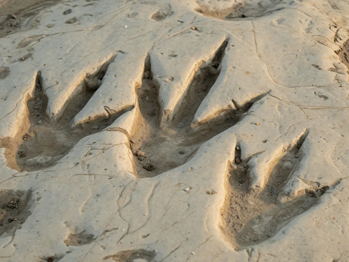
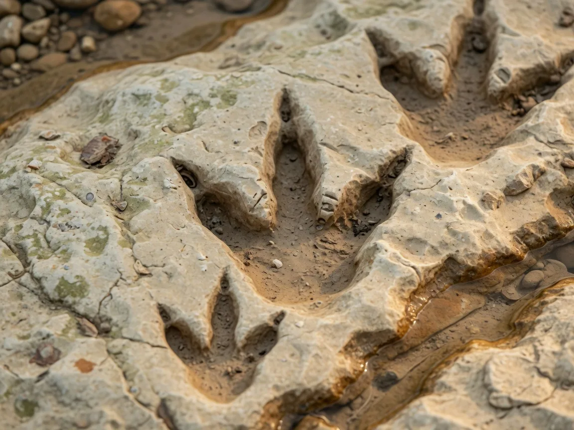
The park's most remarkable discovery came in 2014, when paleontologists working in the bed of Government Canyon Creek uncovered a major theropod trackway — fossilized footprints estimated to be 110 million years old, dating to the Early Cretaceous period [3][4]. The initial discovery of approximately 20 to 25 tracks grew substantially as researchers excavated the site, ultimately revealing more than 170 individual tracks across multiple trackways [3][10].
The tracks are attributed to at least two dinosaur species: Acrocanthosaurus, a large carnivorous theropod that stood roughly 12 feet tall and weighed an estimated 5 to 7 tons, and Sauroposeidon, a massive herbivorous sauropod that could reach lengths of over 100 feet [3][4][10]. The trackways are located along the Discovery Trail, a 1.23-mile accessible path that is the most popular route in the park for families and first-time visitors. Biking is not permitted on the Discovery Trail to protect the fossil site [1][11].
The geological significance of the tracks extends beyond their age. Their location in Government Canyon provides evidence that this area of the Edwards Plateau was once a shoreline of the ancient Gulf of Mexico — a detail that helps explain the limestone marine deposits that form the Edwards Aquifer [3][4]. For anyone interested in understanding how the Hill Country's geology formed and why water behaves the way it does underground, the dinosaur tracks are not just a curiosity — they are a geological clue.
Trail system
With more than 40 miles of trails, Government Canyon offers one of the most extensive hiking and mountain biking networks in the San Antonio–Hill Country region [1][2]. The trails are divided into Frontcountry and Backcountry sections, with difficulty ranging from easy, flat walks to rugged canyon descents and long-distance backcountry loops [1][11].
The most popular routes for day visitors include:
- Discovery Trail — 1.23 miles, Easy. The primary family-friendly route, leading to the dinosaur tracks. Paved and accessible. Biking prohibited [1][11].
- Savannah Loop — 2.6 miles, Easy. A gentle loop through grasslands and light woodland, suitable for all fitness levels. Pets allowed [1][11].
- Lytle's Loop — 5.0 miles, Easy to Moderate. A longer loop that descends into canyon terrain and passes through mixed woodland. Pets allowed [1][11].
- Black Hills Loop — 4.89 miles, Moderate. Steeper terrain with canyon views and more challenging elevation changes [11][12].
- Joe Johnston Route — approximately 6.5 miles, Moderate. Passes the historic 1882 Joe Johnston homestead and extends through varied canyon terrain via the Overlook Trail [1][7].
- Bluff Spurs Trail — 4.0 miles, Moderate to Challenging. Offers some of the best scenic overlooks in the park. Biking prohibited [11][12].
Mountain biking is permitted on approximately 13 designated trails in the park, with the Backcountry section offering the most extensive riding terrain [1][2]. Horseback riding is also allowed on designated trails. Some trails — particularly those in Protected Habitat Areas where endangered karst invertebrates are found — are closed to both biking and pets to preserve fragile ecological conditions [1][7].
Canyon overlooks and geology
The park's canyon system is its defining landscape feature. Deep limestone ravines carved by millennia of water erosion cut through the Edwards Plateau, exposing layered sedimentary rock that tells the geological story of the region [2][5]. Several overlook points along the trail system — particularly along the Bluff Spurs and Overlook trails — provide panoramic views across the canyon and, on clear days, toward the San Antonio skyline to the southeast [12].
The exposed limestone throughout the park is part of the Edwards Group formations, the same porous, fractured rock that constitutes the Edwards Aquifer recharge zone [5][6]. Watching water move through this landscape during or after rainfall — collecting in fractures, disappearing into sinkholes, channeling through canyon floors — is a visible demonstration of how aquifer recharge actually works. For anyone evaluating Hill Country property with a private well or septic system, this kind of on-the-ground geological education is both practical and directly relevant.
Birding and wildlife
The park's diverse habitat — ranging from open grasslands and canyon woodlands to riparian corridors along seasonal creeks — supports a varied bird population. Common sightings include White-tailed Hawks, Golden-fronted Woodpeckers, Black-crested Titmice, and various warbler species during spring and fall migration [1][2]. The canyon terrain provides nesting habitat for raptors, and the creek corridors attract migratory songbirds. Birding is best in the early morning hours, particularly along the Savannah Loop and the lower canyon trails where water sources attract wildlife.
The park is also home to several endangered karst invertebrate species — tiny cave-dwelling organisms found in the fractured limestone and sinkholes of the recharge zone [1][7]. These species, including the Government Canyon Bat Cave meshweaver, are so sensitive to habitat disturbance that their presence determines which trails are open to the public and which are permanently restricted. Understanding that a 12,000-acre public park exists in part to protect organisms measured in millimeters provides a useful sense of how seriously Texas takes aquifer protection [7][8].
Camping
Government Canyon offers 25 walk-in tent campsites and 2 group tent campsites, all located in a designated camping area that requires a short walk (20 to 60 yards) from the parking area [1][13]. The campsites are primitive by design — potable water is available from spigots, but there are no electrical, water, or sewer hookups. The park does not allow RV camping.
Camping is normally available only on Friday and Saturday nights, with additional nights offered around major holidays such as Labor Day, Thanksgiving, and the Christmas/New Year period [1][14]. The nightly fee is $18 per individual campsite and $40 per group campsite [13]. Reservations are recommended and can be made through the Texas State Parks reservation system. The camping area is within the park's Backcountry section, and campers should expect to hike to reach the dinosaur tracks or other trailhead access points [13].
Hours, fees, and practical details
| Detail | Information |
|---|---|
| Address | 12861 Galm Road, San Antonio, TX 78254 |
| Phone | (210) 688-9055 |
| Gate Hours (Fri–Mon) | 7:00 AM – 10:00 PM |
| Gate Hours (Tue–Thu) | 7:00 AM – 8:00 PM |
| Office Hours | 8:30 AM – 4:30 PM daily |
| Day-Use Fee (Ages 13+) | $6.00 per person per day |
| Children 12 & Under | Free |
| Acreage | 12,000+ acres |
| Trail Mileage | 40+ miles |
| Campsite Fee (Individual) | $18 per night (walk-in tent only) |
| Campsite Fee (Group) | $40 per night |
What to bring and practical tips
Clothing and footwear: The canyon terrain is rocky and uneven, with significant elevation changes on the more challenging trails. Closed-toe shoes with ankle support are strongly recommended for anything beyond the Discovery Trail and Savannah Loop [1][11]. Layers are useful in spring and fall when morning temperatures can be noticeably cooler than afternoon highs.
Water: This is non-negotiable. The exposed limestone terrain reflects heat, and the canyon canyons trap warmth. Bring more water than you think you need — at least one liter per person per hour of hiking during warm months. The park does not have food concessions or water stations on the trails beyond the campground spigots [1][11].
Sunscreen and hat: Much of the trail system is exposed, with limited shade cover. The canyon floors offer more tree canopy, but ridgeline trails and overlook points are fully exposed to sun [1][11].
Check trail conditions: Trails may close when wet or muddy to prevent erosion, particularly in the canyon bottoms where water channels through limestone. Call the park at (210) 688-9055 or check the TPWD website before visiting, especially after rainfall [1][11].
Arrive early: The park's most popular trails — particularly the Discovery Trail — can see steady foot traffic on weekend mornings. Arriving when the gate opens at 7:00 a.m. on Friday through Monday provides the best experience, especially during spring and fall [1].
Pets: Dogs are allowed on leash on the Discovery Trail, Savannah Loop, and Lytle's Loop only. Pets are not permitted on other trails, in the Backcountry, or in the camping area [1][7].
Photography: The canyon overlooks are best photographed in the early morning or late afternoon when directional light emphasizes the limestone layering and canyon depth. The dinosaur tracks are best photographed in diffused light to capture the detail of the fossil impressions without harsh shadows [3][4].
Seasonal timing: when to go
| Season | Best Activities | Notes |
|---|---|---|
| Spring Mar – May | Hiking, birding, wildflowers, dinosaur tracks | Best overall season. Mild temperatures, spring wildflowers along canyon trails. Migratory birds arrive March–April. Watch for trail closures after spring rain. |
| Summer Jun – Aug | Early morning hiking, mountain biking | Very hot — trail surfaces radiate heat off exposed limestone. Start at gate opening. Carry extra water. Canyon bottoms are cooler but offer no swimming. |
| Fall Sep – Nov | Hiking, camping, backcountry exploration | Cooler temperatures return September onward. Weekend camping available. Fall migratory birds. Less crowded than spring. |
| Winter Dec – Feb | Hiking, long backcountry loops, photography | Best solitude on trails. Cool but comfortable hiking temperatures. Holiday camping available around Thanksgiving and Christmas. Dec may close for managed deer hunts. |
Why it matters if you are considering the Hill Country
Government Canyon is not a scenic detour — it is an operating demonstration of the most important natural infrastructure system in Central Texas. The Edwards Aquifer, which this park exists to protect, supplies approximately 52% of San Antonio's drinking water and supports springs, wells, and municipal systems across the region [5][6]. The 12,000 acres that make up the park were acquired specifically because they sit on the aquifer's recharge zone — the surface area where water enters the underground limestone system [2][6][8].
For families relocating from California, the Pacific Northwest, or the Northeast, understanding the Edwards Aquifer is not optional — it is foundational. The aquifer determines where wells are drilled, how deep they go, what they cost, and how reliable they are during drought conditions. It shapes septic system engineering, which lot sizes are viable, and which areas are served by municipal water versus private wells. A visit to Government Canyon makes these abstract systems visible and concrete [5][6].
The dinosaur tracks add another layer. The fact that 110-million-year-old footprints of Acrocanthosaurus and Sauroposeidon were found in the creek bed of this park — evidence that the Hill Country was once a Gulf of Mexico shoreline — connects the deep geological past to the present landscape in a way that no textbook can replicate [3][4][10]. Standing on the Discovery Trail and looking at the rock underfoot, understanding that this limestone was once ocean floor, helps explain why the Edwards Aquifer exists, why water behaves the way it does in this terrain, and why the Hill Country's geology is fundamentally different from the Blackland Prairie to the east.
The park's role as a recharge zone protector also matters for anyone evaluating real estate along the Boerne–San Antonio corridor. Properties within or near the Edwards Aquifer recharge zone are subject to specific development regulations enforced by the Edwards Aquifer Authority (EAA) [6]. These regulations affect lot development, septic system permitting, commercial construction, and property values. Seeing the recharge zone in person — understanding its scale, its geology, and its role in the regional water system — provides practical context that directly informs property decisions [5][6].
For a combined day trip, pairing Government Canyon with a visit to the San Antonio Missions National Historical Park (about 20 miles to the east) creates a single outing that covers both the natural and cultural history of the Balcones Escarpment region. Alternatively, combining a morning at Government Canyon with an afternoon at Helotes — a small community just 12 miles west — offers a contrast between protected natural landscape and Hill Country small-town character.
Frequently asked questions
How far is Government Canyon from Boerne?
Approximately 22 miles southeast of downtown Boerne via Highway 87 and I-10, with a drive time of 25 to 35 minutes depending on traffic. The park is closer to San Antonio's northwest side — about 15 miles from the I-10/Loop 1604 interchange [1][9].
How much does it cost to visit?
Day-use admission is $6 per person for ages 13 and older. Children 12 and under enter free. Camping is $18 per night for individual walk-in tent sites and $40 per night for group campsites, in addition to the entrance fee [1][13].
Can I bring my dog?
Dogs on leash are permitted on the Discovery Trail, Savannah Loop, and Lytle's Loop. Pets are not allowed on any other trails, in the Backcountry, or in the camping area [1][7].
Are there dinosaur tracks I can actually see?
Yes. More than 170 theropod and sauropod tracks dating back 110 million years are located along the Discovery Trail, a 1.23-mile accessible path. The tracks were discovered in 2014 in the bed of Government Canyon Creek [3][4][10].
Can I camp at Government Canyon?
Yes, walk-in tent camping is available at 25 individual sites and 2 group sites. Camping is normally restricted to Friday and Saturday nights, with additional nights offered around major holidays. There are no RV hookups — this is primitive tent-only camping [1][13][14].
Is there water or swimming in the park?
There is no swimming or wading in the park. Government Canyon is a natural area focused on aquifer protection — the creek beds that contain the dinosaur tracks are protected geological sites, not recreational swimming areas. Potable water is available at campground spigots [1][7].
Sources
- [1] Texas Parks and Wildlife Department — Government Canyon State Natural Area. tpwd.texas.gov/state-parks/government-canyon
- [2] Trust for Public Land — Government Canyon Natural Area. tpl.org/our-work/government-canyon-natural-area
- [3] Texas Public Radio — Scientists Uncover Dinosaur Tracks at Government Canyon. tpr.org
- [4] Texas Hill Country — Dinosaur Tracks at Government Canyon State Natural Area. texashillcountry.com
- [5] Edwards Aquifer Authority — Learn About the Aquifer. edwardsaquifer.org
- [6] San Antonio Water System — Land Acquisition Program. saws.org
- [7] Texas Parks and Wildlife Department — Government Canyon FAQs. tpwd.texas.gov
- [8] Wikipedia — Government Canyon State Natural Area. en.wikipedia.org
- [9] Incredible Texas — Government Canyon State Natural Area. incredibletexas.com
- [10] TPW Magazine — Dinosaur Tracks at Government Canyon State Natural Area. tpwmagazine.com
- [11] Texas Parks and Wildlife Department — Government Canyon Trails Information. tpwd.texas.gov
- [12] The Texas Trailhead — Government Canyon State Natural Area. thetexastrailhead.com
- [13] Texas State Parks — Government Canyon Campground. texasstateparks.reserveamerica.com
- [14] Texas Parks and Wildlife Department — Government Canyon Holiday Schedule. tpwd.texas.gov
Published July 8, 2026
Updated July 8, 2026