
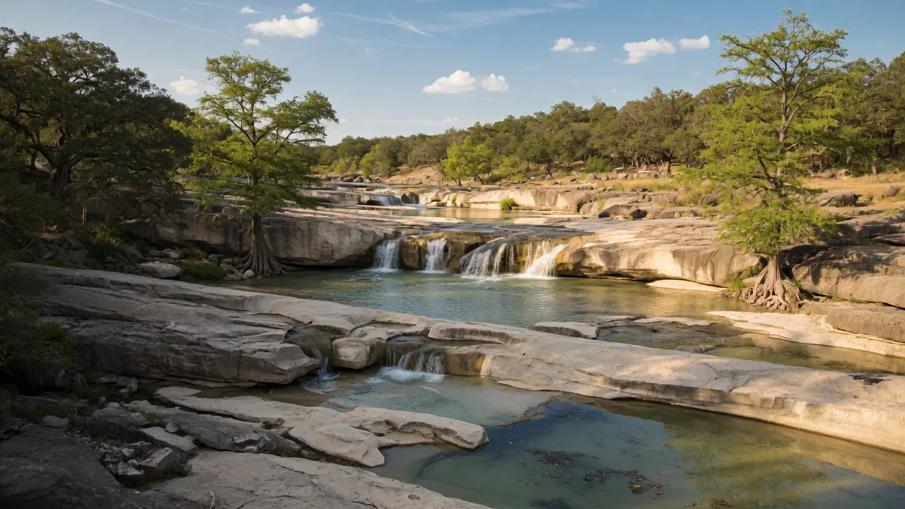
Pedernales Falls State Park sits about 60 miles east of downtown Boerne and offers one of the more dramatic geological experiences in the Texas Hill Country. The park spans 5,212 acres along the Pedernales River in Blanco County, with the centerpiece being a striking series of limestone waterfalls where the river drops roughly 50 feet over three thousand feet of tilted rock shelves [1][2]. The park opened in 1973 and has since become one of the more popular state parks in Central Texas, drawing roughly 300,000 visitors annually [1][3].
For anyone considering a move to the Hill Country, Pedernales Falls is worth understanding for reasons that go well beyond recreation. The rock formations visible at the falls are Marble Falls Limestone, deposited 300 to 320 million years ago when much of Texas sat under a shallow inland sea [4][5]. The same geological layers that create the falls govern well water availability, foundation engineering, and drainage patterns across Blanco County and the wider Hill Country. Seeing the geology in cross-section at the falls makes the subsurface reality of the region plainly visible.
What Pedernales Falls State Park actually is
The park was designated by the Texas Parks and Wildlife Department in 1973 and is located at 2585 Park Road 6026, Johnson City, TX 78636 [1][2]. The primary feature is the falls themselves — a sequence of cascades and plunge pools carved into Marble Falls Limestone that form a dramatic riverine landscape. The park also contains miles of Hill Country terrain including live oak savanna, Ashe juniper woodlands, riparian corridors, and spring-fed creek beds [1][6].
The Pedernales River itself is part of the Colorado River basin and drains an area of over 1,100 square miles across the Edwards Plateau [7]. The river's flow varies dramatically with rainfall — dry summer months can reduce it to a trickle, while heavy rain events can turn the falls into a powerful cascade in a matter of hours. This variability is typical of Hill Country river systems fed by the Edwards Aquifer and its associated springs [4][8].
The park is one of 22 Texas State Parks designated as an International Dark Sky Park by the International Dark-Sky Association (IDA) [1][9]. This designation recognizes the park's commitment to preserving natural nighttime darkness through responsible lighting practices and public education about light pollution. For visitors, it means exceptional stargazing conditions on clear nights.
How to get there from Boerne
From downtown Boerne, the most direct route runs north on US-281 for approximately 45 miles to Johnson City, then east on FM 2766 for about 9 miles to the park entrance [2][10]. The total distance is roughly 60 miles, with a drive time of about one hour to one hour and fifteen minutes under normal conditions.
The US-281 corridor north of Boerne passes through rolling ranchland and small communities including Bergheim and Spring Branch before reaching Johnson City. FM 2766 east of Johnson City is a well-maintained two-lane road that winds through typical Hill Country terrain toward the park entrance [10]. From Fair Oaks Ranch, add roughly five miles and five to eight minutes. From San Antonio's far north side, plan on approximately 75 miles and one hour twenty minutes via I-35 to US-290 West to Johnson City.
| Starting Point | Distance | Drive Time |
|---|---|---|
| Downtown Boerne | ~60 miles | ~60–75 min |
| Fair Oaks Ranch | ~65 miles | ~65–80 min |
| Johnson City | ~9 miles | ~12–15 min |
| San Antonio (I-35 corridor) | ~75 miles | ~80–90 min |
| Austin | ~65 miles | ~70 min |
Distances are approximate and based on standard driving routes.
What to see and do
The falls
The primary attraction is the falls area, where the Pedernales River flows over a broad expanse of tilted Marble Falls Limestone. The rock shelves drop approximately 50 feet over the course of three thousand feet, creating a series of cascades, step pools, and smooth rock slides that vary dramatically with water flow [1][2]. A quarter-mile paved trail from the parking area leads to the main overlook and provides access to the rock shelf area [11].
It is worth emphasizing: swimming, wading, and tubing are strictly prohibited at the falls themselves. The water flow is unpredictable, currents can form in deeper channels, and flash flooding is a real risk when storms move through the upstream watershed [1][12]. This is not a casual restriction — the river can rise several feet in minutes during a storm event, even when the weather at the park appears clear. Visitors are asked to stay on the designated rock shelf areas and out of the pools closest to the main falls [12].
Swimming at the designated beach area
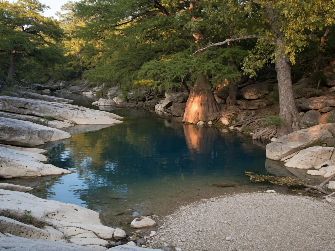
Swimming is permitted at a designated beach area located downstream from the falls, accessible via a quarter-mile hike with a set of steep rock stairs [1][12]. This area is between Trammell's Crossing and the youth camping area, where the river widens and the current is gentler. The water here is typically clear and spring-fed, with limestone gravel and sand forming a natural beach. The stairs can be challenging on the return trip, particularly in hot weather, so bringing water and taking it slow is advised [12][13].
Hiking trails
The park contains over 20 miles of hiking trails ranging from easy riverside walks to strenuous backcountry loops [1][14]. Key trails include:
- Wolf Mountain Trail (6-mile loop, moderate to strenuous) — The park's most popular long trail, crossing open savanna, limestone outcrops, and offering views of the Pedernales River valley. A spring-fed pool about halfway through provides a reliable water source and a good turnaround point [14][15].
- Twin Falls Nature Trail (0.5-mile loop, easy) — A short, accessible loop that follows a creek bed to two small seasonal cascades. Good for families with young children or anyone wanting a quick walk [14].
- Juniper Ridge Trail (10-mile loop, strenuous) — The park's longest and most demanding trail, following a ridgeline through dense juniper and oak woodland with significant elevation changes. Best attempted by experienced hikers with plenty of water [14][15].
- Trammell's Crossing Trail (5-mile round trip, moderate) — Follows the river downstream from the falls to a historic river crossing. This trail passes through the swimming beach area and is one of the better routes for combining hiking with a swim stop [14][15].
- The Loop Trail (5.5-mile loop, moderate) — A Hill Country ridge trail that connects the falls overlook to the park's backcountry terrain with good birding and wildflower opportunities in spring [14].
Equestrian trails
The park offers approximately 10 miles of designated equestrian trails in its western section, separate from the primary hiking trail system [1][16]. Horses are not available for rent — riders must bring their own. Parking for horse trailers is available at the equestrian staging area.
Mountain biking
Mountain biking is permitted on the park's paved and gravel roads but not on the hiking or equestrian trails. The roads provide a moderate workout with Hill Country climbs [1].
Stargazing
As an International Dark Sky Park, Pedernales Falls is one of the better stargazing destinations within driving distance of Boerne [1][9]. The park is open until 10 p.m., which is late enough during longer evenings to allow for significant sky viewing after sunset. The park's amphitheater area and the open rock shelf near the falls overlook are popular spots for astronomy. New moon weekends offer the darkest skies. The park occasionally hosts ranger-led stargazing programs — checking the TPWD events calendar in advance is worthwhile [9][17].
Wildlife and birding
The park's diverse habitat supports a wide range of wildlife including white-tailed deer, wild turkey, armadillos, and the occasional fox or coyote [1][6]. Over 150 bird species have been documented, including Golden-cheeked Warblers, Black-capped Vireos, and Painted Buntings [6][18]. Spring migration (April through May) offers the best birding. A park bird checklist is available at the headquarters.

Camping and overnight options
The park has multiple camping options, from full-hookup RV sites to primitive walk-in sites [1][19]. All camping fees are in addition to the daily entrance fee. Reservations are strongly recommended, particularly during spring and fall weekends.
| Campsite Type | Nightly Rate | Notes |
|---|---|---|
| Primitive Walk-In Sites | $10.00 | Short walk from parking; no water or electric |
| Water / Electric Sites | $20.00 | 30-amp electric; suitable for RVs and tents |
| Screened Shelters | $40.00 | Roofed with screens; includes bed frames |
| Equestrian Primitive Sites | $15.00 | Horse trailer accessible; no hookups |
All camping fees are in addition to the $6/day per-person entrance fee (ages 13+). Children 12 and under are free. Rates subject to change.
Hours, fees, and practical details
| Detail | Information |
|---|---|
| Address | 2585 Park Road 6026, Johnson City, TX 78636 |
| Phone | (830) 868-7304 |
| Gate Hours | 8:00 AM – 10:00 PM daily |
| Office Hours | 8:00 AM – 4:30 PM daily |
| Day-Use Fee (Ages 13+) | $6.00 per person per day |
| Children 12 & Under | Free |
| Acreage | 5,212 acres |
| Designation | International Dark Sky Park |
| Trails | 20+ miles hiking, 10 miles equestrian |
| Reservations | Recommended for camping; day use not required |
What to bring and practical tips
Footwear for the falls: The limestone rock shelf at the falls can be uneven and slippery, especially where water is present. Water shoes or sturdy sandals with good grip are recommended if you plan to walk on the rock shelves. For the hiking trails, closed-toe hiking shoes with ankle support are ideal [1][13].
Water and sun protection: Much of the park is exposed Hill Country terrain with limited shade on the ridges. Summer temperatures regularly exceed 95 degrees Fahrenheit. Bringing at least one gallon of water per person for a full day of hiking is not excessive. Sunscreen, a hat, and light long-sleeved clothing help significantly [1][13].
Swimming gear: The designated swimming beach downstream is worth packing for if you are visiting between May and October. The water is spring-fed and clear but can be cool even in summer — a dry change of clothes makes the drive home more comfortable [12][13].
Snacks and meals: There are no food concessions inside the park. Packing a cooler with lunch and plenty of snacks is standard practice. Several picnic areas with tables and grills are available on a first-come basis [1]. Johnson City has a handful of restaurants and convenience stores about 15 minutes before the park entrance if you need supplies.
Reservations for camping: Weekend campsites and screened shelters fill well in advance during spring and fall, the two most popular seasons. Booking through the Texas State Parks reservation system as early as possible is recommended [19].
Photography: The falls area is most photogenic in the early morning or late afternoon when the low sun angle highlights the limestone texture and creates reflections in the pools. A polarizing filter can help reduce glare off the water. For stargazing photography, the dark-sky designation means minimal light pollution — a tripod and a wide-aperture lens will produce good results on moonless nights [9][17].
Pets: Pets are permitted on leashes in the park but are not allowed in the swimming area or on the rock shelf at the falls [1].
Flash flooding awareness: The Pedernales River is prone to rapid flash flooding during rain events, even when skies are clear at the park. Check the weather forecast for the upstream watershed before visiting, and if you hear thunder or notice the water beginning to rise and turn muddy, move to higher ground immediately [1][12].
Seasonal timing: when to go
| Season | Best Activities | Notes |
|---|---|---|
| Spring Mar – May | Falls viewing, hiking, wildflowers, birding | Peak water flow at falls. Wildflowers peak late March–April. Best bird migration window. Mild hiking temperatures. |
| Summer Jun – Aug | Swimming at beach area, early morning hiking, stargazing | Lowest water flow at falls. Swimming beach is the primary draw. Arrive early. Hot midday — aim for morning or evening visits. Dark-sky programs on clear nights. |
| Fall Sep – Nov | Hiking, camping, falls viewing, stargazing | Cooler temperatures and fewer crowds. Best all-around season. Fall foliage along the river corridor in October–November. |
| Winter Dec – Feb | Hiking, stargazing, solitude | Quietest season. Best stargazing with longest nights. Cold temperatures but generally clear. Falls can still flow well after rain events. |
Why it matters if you are considering the Hill Country
Pedernales Falls State Park is one of the most visible and accessible examples of the Hill Country's deep-time geology. The Marble Falls Limestone visible at the falls was formed in a shallow sea more than 300 million years ago, long before the dinosaurs, and was subsequently tilted, faulted, and exposed by millions of years of erosion [4][5]. The same limestone formations underlie much of Blanco County and the wider Edwards Plateau region. For anyone evaluating land or property in the Hill Country, the rock layers visible at the falls are the same layers that determine well yields, foundation conditions, karst features like caves and sinkholes, and the movement of groundwater through the Edwards Aquifer system [4][8].
The park's function as a dark-sky preserve adds another dimension. Light pollution is a growing concern across Texas, and the ability to see the Milky Way from a developed state park within an hour of two major cities (Austin and San Antonio) is something that distinguishes this part of the state from most other metropolitan regions. For families weighing a move from California, the Pacific Northwest, or the Northeast, the proximity of genuine dark-sky viewing to suburban and exurban living is a quality-of-life factor that does not show up on a listing sheet [9][17].
The Pedernales River itself tells the story of water in the Hill Country. The river's flow is highly variable — it can be a full, flowing river in spring and a series of disconnected pools by late summer. This variability reflects the region's reliance on seasonal rainfall and aquifer recharge. Understanding how the river behaves is directly relevant to understanding the water systems that serve homes and properties in the area, from well water availability to surface water rights to the challenges of managing a rural property's water supply through drought cycles [4][8].
For a combined day trip from Boerne, pairing Pedernales Falls with a stop in Johnson City (about 15 minutes west of the park) makes practical sense. Johnson City's LBJ State Park and the Lyndon B. Johnson National Historical Park offer a look at the cultural and political history of the Hill Country, creating a single outing that covers both natural and human history. On the wine-and-food side, the stretch of US-290 between Johnson City and Fredericksburg is lined with Texas wineries and tasting rooms, making for an easy addition if a longer day is the plan.
Frequently asked questions
How far is Pedernales Falls State Park from Boerne?
Approximately 60 miles east of downtown Boerne via US-281 North to Johnson City, then FM 2766 east for about 9 miles. The drive takes roughly one hour to one hour and fifteen minutes under normal conditions [2][10].
Can you swim at Pedernales Falls State Park?
Yes, but only in the designated swimming beach area downstream from the falls, accessible via a quarter-mile hike with steep stairs. Swimming, wading, and tubing are strictly prohibited at the falls themselves due to dangerous currents and flash-flood risk [1][12].
How much does it cost to visit?
Day-use admission is $6 per person for ages 13 and older. Children 12 and under are free. Camping fees range from $10 to $40 per night depending on site type, in addition to the entrance fee [1][19].
What makes the geology at Pedernales Falls special?
The falls expose Marble Falls Limestone that formed 300 to 320 million years ago in a shallow sea. The limestone shelves are tilted at an angle, creating a stepped waterfall effect as the river flows over them. Marine fossils can be found embedded in the rock. The same geological layers underlie much of the Hill Country and directly influence well water, groundwater movement, and foundation conditions [4][5].
Is Pedernales Falls good for stargazing?
Yes. Pedernales Falls is designated as an International Dark Sky Park by the International Dark-Sky Association. The park maintains responsible lighting to preserve natural nighttime darkness, and on clear, moonless nights it offers excellent views of the Milky Way. New moon weekends provide the best conditions [1][9].
What is the best hiking trail in the park?
The Wolf Mountain Trail (6-mile loop) is the most popular and rewarding hike, crossing open savanna and providing views of the river valley. For a shorter option, the Twin Falls Nature Trail (0.5-mile loop) is easy and family-friendly. Experienced hikers looking for a challenge can try the Juniper Ridge Trail (10-mile loop) [14][15].
Sources
- [1] Texas Parks and Wildlife Department — Pedernales Falls State Park. tpwd.texas.gov/state-parks/pedernales-falls
- [2] Wikipedia — Pedernales Falls State Park. en.wikipedia.org/wiki/Pedernales_Falls_State_Park
- [3] Austin American-Statesman — Pedernales Falls attendance data. statesman.com
- [4] USGS / SERC Carleton — Central Texas Field Stops: Pedernales Falls geology. serc.carleton.edu
- [5] Geology Virtual Trips — Pedernales Falls, Texas. geologyvirtualtrips.com/pedernales
- [6] TPWD — Pedernales Falls State Park Nature. tpwd.texas.gov
- [7] Texas Water Development Board — Pedernales River Basin. twdb.texas.gov
- [8] Edwards Aquifer Authority — About the Aquifer. edwardsaquifer.org
- [9] International Dark-Sky Association — Pedernales Falls State Park Dark Sky Park. darksky.org
- [10] TPWD — Pedernales Falls State Park Map. tpwd.texas.gov
- [11] AllTrails — Pedernales Falls Trail. alltrails.com
- [12] StayTexas — Everything You Need to Know Before You Visit Pedernales Falls State Park. staytexas.com
- [13] Texas State Parks — Pedernales Falls Park Guide. tpwd.texas.gov
- [14] Pedernales Falls Guide — Hiking Trails. pedernalesfalls.com
- [15] AllTrails — Best Trails in Pedernales Falls State Park. alltrails.com
- [16] Texas State Parks — Equestrian Trails at Pedernales Falls. tpwd.texas.gov
- [17] TPWD — Dark Sky Parks in Texas. tpwd.texas.gov
- [18] eBird — Pedernales Falls State Park hotspot. ebird.org
- [19] ReserveAmerica — Pedernales Falls State Park Camping. texasstateparks.reserveamerica.com
Published July 24, 2026
Updated July 24, 2026